Enregistrez gratuitement cette image
en 800 pixels pour usage maquette
(click droit, Enregistrer l'image sous...)
|
|
Réf : T01456
Thème :
Terre vue de l'espace - Villes (375 images)
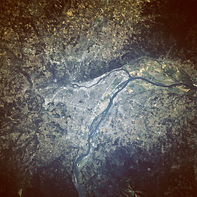
Titre : Portland and Willamette River, Oregon, U.S.A. September 1992
Description : (La description de cette image n'existe qu'en anglais)
This west-looking, low-oblique photograph shows the metropolitan area of the City of Roses, Portland, Oregon. South of the Columbia River (center of the photograph), Portland lies on the Willamette River just 10 miles (16 kilometers) from the river’s confluence with the Columbia River. Portland, an important deepwater port with many shipyards, is also a leading financial and industrial center. Manufacturing industries include lumber, wood products, paper, metals, machinery, foodstuffs, woolen textiles, clothing, electronic components, dairy products, paint, and furniture. The city served as a major supply center during the gold rushes in California in the late 1840s and in Alaska in the late 1880s and 1890s. Vancouver, Washington, visible on the north bank of the Columbia River opposite Portland, is also a deepwater port with many shipyards, shipbuilding facilities, lumber mills, and an enormous grain elevator. Vancouver is headquarters for the Gifford Pinchot National Forest in which Mount Saint Helens Volcano is located. The Willamette River, 294 miles (473 kilometers) long, rises in the Cascade Range of southern Oregon and flows north through the wide, fertile Willamette Valley, a major fruit-growing and dairy-producing region. Numerous dams and reservoirs have harnessed the river and its tributaries to provide flood control, navigation, and hydroelectric power production.
|
|

